🚚 Free Worldwide Shipping on All Orders!Shop Now

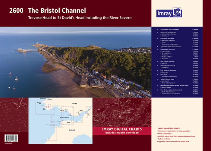
Imray Chart 2600 Bristol Channel Chart Pack
The chart specification has been improved to show coloured light flashes. There has been general updating throughout.
Individual charts from this atlas are no longer available to purchase separately - Chart Y26 contains coverage of Milford Haven and River Cleddau to Haverfordwest (also covered by sheets 2600.11 and 2600.12)
The atlas contains 12 sheets-
2600.1 Trevose Head to St David’s Head 1:450, 000 WGS 84
2600.2 Padstow to Hartland Point 1:120, 000 WGS 84
Plans Approaches to Padstow, Bude Haven
2600.3 Hartland to Ilfracombe 1:140, 000 WGS 84
Plans Barnstaple to Bideford, Lundy, Continuation to Barnstaple
2600.4 Approaches to the Bristol Channel 1:130, 000 WGS 84
2600.5 Ilfracombe to Nash Point 1:130, 000 WGS 84
Plans The Mumbles, Swansea Marina, Porthcawl, Ilfracombe
2600.6 Nash Point to Flat Holm 1:80, 000 WGS 84
Plans Watchet
2600.7 Flat Holm to Avonmouth 1:70, 000 WGS 84
Plans Cardiff Bay
2600.8 River Severn to Sharpness 1:50, 000 WGS 84
Plans Sharpness
2600.9 River Avon 1: 20, 000 WGS 84
Plans River Avon (continuation)
2600.10 Tenby to Skomer Island 1:135 000 WGS 84
Plans Jack Sound, Tenby & Caldey Island
2600.11 Milford Haven - St Ann’s Head to Neyland Point 1:30, 000 WGS 84
Plans Milford Marina
2600.12 River Cleddau - above Neyland Point 1:25, 000 WGS 84
Plans Neyland Yacht Haven, Continuation to Haverfordwest
Imray Digital Charts: Free mobile download
A voucher code to download the relevant Imray digital charts into our Imray Navigator app is included with this atlas.
Individual charts from this atlas are no longer available to purchase separately - Chart Y26 contains coverage of Milford Haven and River Cleddau to Haverfordwest (also covered by sheets 2600.11 and 2600.12)
The atlas contains 12 sheets-
2600.1 Trevose Head to St David’s Head 1:450, 000 WGS 84
2600.2 Padstow to Hartland Point 1:120, 000 WGS 84
Plans Approaches to Padstow, Bude Haven
2600.3 Hartland to Ilfracombe 1:140, 000 WGS 84
Plans Barnstaple to Bideford, Lundy, Continuation to Barnstaple
2600.4 Approaches to the Bristol Channel 1:130, 000 WGS 84
2600.5 Ilfracombe to Nash Point 1:130, 000 WGS 84
Plans The Mumbles, Swansea Marina, Porthcawl, Ilfracombe
2600.6 Nash Point to Flat Holm 1:80, 000 WGS 84
Plans Watchet
2600.7 Flat Holm to Avonmouth 1:70, 000 WGS 84
Plans Cardiff Bay
2600.8 River Severn to Sharpness 1:50, 000 WGS 84
Plans Sharpness
2600.9 River Avon 1: 20, 000 WGS 84
Plans River Avon (continuation)
2600.10 Tenby to Skomer Island 1:135 000 WGS 84
Plans Jack Sound, Tenby & Caldey Island
2600.11 Milford Haven - St Ann’s Head to Neyland Point 1:30, 000 WGS 84
Plans Milford Marina
2600.12 River Cleddau - above Neyland Point 1:25, 000 WGS 84
Plans Neyland Yacht Haven, Continuation to Haverfordwest
Imray Digital Charts: Free mobile download
A voucher code to download the relevant Imray digital charts into our Imray Navigator app is included with this atlas.
$25.78
Original: $73.66
-65%Imray Chart 2600 Bristol Channel Chart Pack—
$73.66
$25.78Product Information
Product Information
Shipping & Returns
Shipping & Returns
Description
The chart specification has been improved to show coloured light flashes. There has been general updating throughout.
Individual charts from this atlas are no longer available to purchase separately - Chart Y26 contains coverage of Milford Haven and River Cleddau to Haverfordwest (also covered by sheets 2600.11 and 2600.12)
The atlas contains 12 sheets-
2600.1 Trevose Head to St David’s Head 1:450, 000 WGS 84
2600.2 Padstow to Hartland Point 1:120, 000 WGS 84
Plans Approaches to Padstow, Bude Haven
2600.3 Hartland to Ilfracombe 1:140, 000 WGS 84
Plans Barnstaple to Bideford, Lundy, Continuation to Barnstaple
2600.4 Approaches to the Bristol Channel 1:130, 000 WGS 84
2600.5 Ilfracombe to Nash Point 1:130, 000 WGS 84
Plans The Mumbles, Swansea Marina, Porthcawl, Ilfracombe
2600.6 Nash Point to Flat Holm 1:80, 000 WGS 84
Plans Watchet
2600.7 Flat Holm to Avonmouth 1:70, 000 WGS 84
Plans Cardiff Bay
2600.8 River Severn to Sharpness 1:50, 000 WGS 84
Plans Sharpness
2600.9 River Avon 1: 20, 000 WGS 84
Plans River Avon (continuation)
2600.10 Tenby to Skomer Island 1:135 000 WGS 84
Plans Jack Sound, Tenby & Caldey Island
2600.11 Milford Haven - St Ann’s Head to Neyland Point 1:30, 000 WGS 84
Plans Milford Marina
2600.12 River Cleddau - above Neyland Point 1:25, 000 WGS 84
Plans Neyland Yacht Haven, Continuation to Haverfordwest
Imray Digital Charts: Free mobile download
A voucher code to download the relevant Imray digital charts into our Imray Navigator app is included with this atlas.
Individual charts from this atlas are no longer available to purchase separately - Chart Y26 contains coverage of Milford Haven and River Cleddau to Haverfordwest (also covered by sheets 2600.11 and 2600.12)
The atlas contains 12 sheets-
2600.1 Trevose Head to St David’s Head 1:450, 000 WGS 84
2600.2 Padstow to Hartland Point 1:120, 000 WGS 84
Plans Approaches to Padstow, Bude Haven
2600.3 Hartland to Ilfracombe 1:140, 000 WGS 84
Plans Barnstaple to Bideford, Lundy, Continuation to Barnstaple
2600.4 Approaches to the Bristol Channel 1:130, 000 WGS 84
2600.5 Ilfracombe to Nash Point 1:130, 000 WGS 84
Plans The Mumbles, Swansea Marina, Porthcawl, Ilfracombe
2600.6 Nash Point to Flat Holm 1:80, 000 WGS 84
Plans Watchet
2600.7 Flat Holm to Avonmouth 1:70, 000 WGS 84
Plans Cardiff Bay
2600.8 River Severn to Sharpness 1:50, 000 WGS 84
Plans Sharpness
2600.9 River Avon 1: 20, 000 WGS 84
Plans River Avon (continuation)
2600.10 Tenby to Skomer Island 1:135 000 WGS 84
Plans Jack Sound, Tenby & Caldey Island
2600.11 Milford Haven - St Ann’s Head to Neyland Point 1:30, 000 WGS 84
Plans Milford Marina
2600.12 River Cleddau - above Neyland Point 1:25, 000 WGS 84
Plans Neyland Yacht Haven, Continuation to Haverfordwest
Imray Digital Charts: Free mobile download
A voucher code to download the relevant Imray digital charts into our Imray Navigator app is included with this atlas.